Showing posts with label wetlands. Show all posts

Monday, October 4, 2010

Ridgewood Reservoir: Wilderness at the Edge of Bushwick by Katharine Jose | Capital New York

Read original...

The Ridgewood Reservoir. Photo by Katharine Jose

On a 50-acre piece of land on the border between Brooklyn and Queens is three-basin reservoir that was once part of the Brooklyn water supply system, and that hasn’t been touched in at least 40 years. Inside the chain-link fence around it is an impossible landscape: thick forest, wet meadows, a small lake ringed with reeds; the Ridgewood Reservoir has been restoring itself to its original ecology for decades. Standing in the right place on the 1.25 mile path, the place smells, sounds and looks like the marshes on the coast of New England. And it’s virtually unknown.


Click here to read more...

Tuesday, May 11, 2010

New York State DEC Wetlands Investigation Comes After Years of Rapid Change by Matthew Bultman - Leader-Observer

Read original...

The Ridgewood Reservoir was only decommissioned in 1989. So how is it possible that just two decades later the state Department of Environmental Conservation (DEC) is considering the site for potential wetlands status?

The answer says as much about the changing nature of New York City's landscape as it does about the possible struggle between the Bloomberg Administration and the state over control of the reservoir, where a wetlands designation could impinge on city plans for a $26 million upgrade.

The reservoir could be ripe for wetlands designation today precisely because of its rapid transformation over the past 20 years, said DEC spokesman Thomas Panzone.

“In the years since the reservoir was decommissioned, the basins, or parts of the basins, have developed some wetland characteristics such as seasonally or permanently wet areas and wetland-dependent vegetation,” Panzone said in an email.

There are currently 21 designated wetlands in Queens consisting of a total of 260 acres, or less than one percent of the total land in the borough. The DEC defines a wetland as a transition area between uplands and aquatic habitats. While standing water is often a sign of a wetland, it doesn’t have to be present in order for a wetland to exist.

Wetlands are valuable in the sense they provide the community with a variety of services, including flood and storm control, as well as a productive wildlife habitat. The reservoir is currently home to over 100 species of birds, many of which may be in danger if the wetland were altered.

Panzone said the final decision of whether or not to label the area as a wetland will rest upon the basic characteristics of the reservoir's basins and whether or not they match the criteria set by the DEC for qualification as a wetland.

The DEC is continuing to gather information on the basins to determine whether or not it meets that criteria.

The city's $26 million upgrade would involve building a recreation area over a portion of the reservoir's third basin, a move that is unpopular with local residents and preservationists.

But Panzone said the city’s plan was not the reason for the DEC’s wetland designation investigation. “The DEC has received letters of concern about the Ridgewood Reservoir over the past couple years,” Panzone said. “This included a request to designate the area as a wetland.”

Panzone said a wetlands designation might not interfere with the city's plans, depending on what the city intends to do with the site.

“The Freshwater Wetlands Act and regulations are designed to ensure that activities within a 100-foot ‘adjacent area’ around a wetland do not result in harm to wetland functions and values,” Panzone said. “Public park-related activities can often be designed carefully enough to be compatible with these legal standards.”

He said that a specific timetable for a decision by the DEC has not been made.

“In the meantime, however,” he said, “the DEC has communicated to the Department of Parks and Recreations its interest in the area and the advisability of considering designs that will protect the natural resources in the area.”

The 50-acre Ridgewood Reservoir on the Brooklyn-Queens border was an active water source until 1959. It served as a backup reservoir for Queens and Brooklyn until it was decommissioned three decades later.

Friday, May 7, 2010

Debate Over Wetlands Stalls Ridgewood Reservoir Fixup by Lisa M. Colangelo - NY Daily News

Read original...

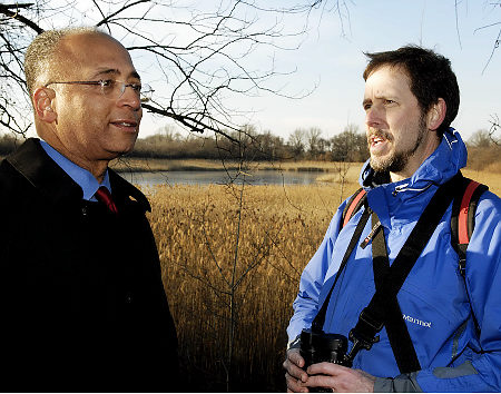
William C. Thompson walks through the Ridgewood Reservoir with preservation community member Rob Jett, talking about the importance of preserving and maintain the area. Koester for News


Plans to redevelop the Ridgewood Reservoir site are on hold while state officials decide whether it should be designated a wetlands area.

The city Parks Department had been poised to unveil three potential redesigns for the site. But officials said that won't happen until the state Department of Environmental Conservation makes its decision.

"The DEC has received letters of concern about the Ridgewood Reservoir over the past couple of years, including a request to designate the area as a wetland," said DEC spokeswoman Maureen Wren.

"More information is being gathered to determine whether or not it meets criteria for state mapping as a wetland," she said.

The decommissioned reservoir, which straddles the Brooklyn-Queens border, is made up of three basins on 50 acres of land.

Nature has reclaimed the site and the basins are filled with various trees, mosses and wetland plants.

The city has been mulling plans to transform the area into a park and possibly place much-needed sports fields on the grounds.

But local residents and elected officials have been lobbying to keep the reservoir a wild nature preserve.

"The community has said all along that this is wetlands and it should be protected," said David Quintana, a local activist. "The money they are wasting on designs and other things should go toward renovating the fields that exist at Highland Park."

Parks officials said this week they are pushing ahead with plans to fix perimeter paths and lighting around the reservoir.

"We're working closely with the city Department of Environmental Protection and state Department of Environmental Conservation to investigate conditions on the site," the Parks Department said in a statement. "The environmental considerations at this site have been taken into account since the start of the project."

Thursday, May 6, 2010

State Agency Eyes Ridgewood Reservoir As Possible Wetland by Robert Pozarycki - www.timesnewsweekly.com | Times Newsweekly

Read original...

First Phase Of Project Moves Forward

Though the New York State Department of Environmental Conservation (DEC) is considering instituting wetland status to the Ridgewood Reservoir on the Brooklyn/Queens border, the New York City Parks Department maintains that the first phase of improvements to the site will be moving as scheduled.

According to a DEC statement sent to the Times Newsweekly, the agency is currently reviewing the 55- acre site adjacent to the Jackie Robinson Parkway and Vermont Place as a possible “state-regulated freshwater wetland.” If the site is given that designation, the state DEC would have the authority to review any potential activities at the reservoir and require permits for any specific improvements.

In a statement, the Parks Department indicated that the agency has been working closely with the DEC and the city Department of Environmental Protection “to investigate conditions on the site,” adding that “[t]he environmental conditions at this site have been taken into account since the start of the project.”

Even with the DEC review underway, the Parks Department noted that it intends to start the first phase of improvements to the Ridgewood Reservoir beginning this fall. The work includes the installation of new fencing around the former basins as well, new lighting as improvements to the pathway around the perimeter of the site.

The agency’s review has become a cause of concern for those close to the project. Gary Giordano, district manager of Queens Community Board 5, told the Times Newsweekly that he would contact state and city officials in the weeks ahead to ascertain further information regarding the DEC’s concerns and how the Parks Department will move forward with improvements.

Plans for the redevelopment of the Ridgewood Reservoir as a public park have been the subject of much controversy since 2004, the year when Mayor Michael Bloomberg transferred control of the property from the DEP to the Parks Department.

Defunct since 1989, the reservoir has naturally evolved over the last two decades to become a habitat for various plant and wildlife. The center basin of the reservoir’s three chambers remains filled with water and resembles a natural lake.

As part of its PlaNYC 2030 master plan, the city announced in 2007 that it would redevelop the Ridgewood Reservoir as well as the adjacent Highland Park, making it one of eight “regional parks” around the city. Initial plans called for one of the reservoir’s three basins to be cleared and developed with new ball fields and play areas.

Community activists voiced opposition to the plans, observing that the reservoir should remain at a nature preserve and that ball fields at Highland Park should be improved instead. Numerous community meetings were held by the Parks Department over the last several years, gathering opinions from residents in both Brooklyn and Queens.

Wednesday, April 28, 2010

Wetlands Designation Right for Ridge Reservoir - Queens Ledger

Read original...

We welcome the news that the state is considering protecting the Ridgewood Reservoir with a wetlands designation. It would be the right thing to do, for several reasons.

First, the reservoir- with its beautiful, lake-like second basin and winding pathways- is a gem of a natural habitat the likes of which can never be replaced. The site is home to over 100 species of birds, other animals and a rich variety of flora. It is a community resource, and by any measure more-than-deserving of environmental oversight and protection.

The issue of preservation hits roundly on the second- and perhaps most important- reason why the state plan makes sense. If the DEC classifies the site as a state-regulated wetlands, that could impede the city from pursuing a misguided redevelopment plan for the site, one that has been soundly rejected by the community board and neighborhood preservationists alike.

To be fair, the city isn't planning to raze the reservoir and replace it with high-rise apartment buildings or a large mall. But the city's vision for the reservoir- the final version of which has not been chosen, or made public- suggests a keen desire to build ball fields on the reservoir's third basin.

This makes no sense. It would disrupt the site's fragile ecosystem, and does not take into account Highland Park, which is adjacent to the reservoir and has plenty of recreational areas of its own. If the city, in these tough fiscal times, is committed to spending millions of dollars on a parks project on the border of Queens and Brooklyn, why not invest the money in improving Highland Park and leave the reservoir alone?

In that scenario, the entire site could be converted into a nature preserve with educational facilities, as many wish. The Bloomberg Administration, though, is not known for backing development compromises when it could instead spend more money, and build new projects.

So unless the state steps in, its very likely the city will proceed with its plans, regardless of any opposition to them. It is still unclear how a wetlands designation would impact the city's plans. And of course the DEC might decide not to follow through with the wetlands designation after all.

But if it does, that might be enough to protect the reservoir for generations of Queens and Brooklyn residents. And we might get an improved Highland Park in the bargain. How about that?

Thursday, April 22, 2010

State Eyeing Ridgewood Reservoir for Wetlands Protection by Dan Bush - Queens Ledger

Read original....


The Department of Environmental Conservation (DEC) is considering classifying the Ridgewood Reservoir a state-regulated freshwater wetlands, this paper has learned.

The designation would subject the city's planned redevelopment of the reservoir to a state review, and would set the stage for a possible confrontation over the site with the Bloomberg Administration.

The city is planning a $26 million project that would convert part of the three-basin reservoir into a recreation area, despite objections from residents who want the site protected as a natural preserve.

Thomas Panzone, a DEC spokesperson, confirmed the state is eyeing the 160-year-old reservoir, which was decommissioned in 1989 and has reverted back into unkempt parkland.

“DEC is reviewing whether or not the Ridgewood Reservoir should be classified as a state-regulated freshwater wetland,” Panzone said in an email. If that happens any planned changes to the site would be subject to review by the state, and could require a permit under the state's Freshwater Wetland regulations, he said.

The Parks Department was not immediately available for comment.

The full implications of a wetlands designation on the city's plans for the reservoir remain unclear. But someone with knowledge of the negotiations between the city and state said the DEC's interest has complicated the city's efforts to remake the reservoir.

It appears likely the city could proceed easily with its phase one plans - to upgrade lights and fencing around the reservoir and rebuild a pathway between the second and third basins - regardless of any state involvement.

But the thought of complex wetlands regulations has raised concerns inside the Parks Department over its phase two plans to replace part of the third basin with an active recreation area. The work could prove difficult if the site were protected.

The phase two plan is deeply unpopular with local preservationists and Community Board 5, which recommended improving the existing ball fields in adjacent Highland Park instead of building new ones inside the reservoir.

“We'd like to see it be a nature preserve,” said Gary Giordano, CB5's district manager. If the wetlands designation allows for passive recreation on the reservoir's pathways “that's a lot more palatable than any kind of recreation development inside the reservoir,” he said.

Assemblyman Mike Miller said a state-regulated wetlands would provide important protection for wildlife within the reservoir, home to over 100 bird species. “It would curtail some of the changes the parks department wants to make,” Miller said, “but it would protect the basins the community wants protected.”

Monday, May 25, 2009

Setting the Stage for Conservation by Willow Belden - Queens Chronicle

Read original...

New York City used to have over 300,000 acres of wetlands; today, less than one-tenth remain, due to development projects that have taken place over the past 150 years. Various federal and state laws regulate development in wetland areas, but there are gaps in the rules, which means many of the city’s marshy areas fall through the cracks.

To try to close the regulatory loopholes, the City Council recently passed a bill requiring that the city identify and document all remaining wetlands and develop a comprehensive conservation strategy for them. The goal is to prevent further net loss of wetlands in the city.

The bill passed unanimously in the council, and the mayor is expected to sign the legislation on Tuesday.

You might think the bill isn’t proposing anything that new. After all, don’t we already know where the city’s wetlands are?

“No, we don’t,” said Councilman James Gennaro (D-Fresh Meadows), chairman of the Environmental Protection Committee and author of the bill. “We know generally where they are, but generally knowing where they are is different than making a precise inventory and doing a detailed delineation of them.”

The state Department of Environmental Conservation inventoried and mapped the city’s tidal wetlands in 1975 and did the same for freshwater wetlands twice in the 1980s. But that was the last comprehensive documentation, and in 30-some years, the size and quantity of wetlands can change significantly.

Documentation is the first step in developing a conservation program for wetlands, according to Dan Montella, chief of the wetlands protection team for the Environmental Protection Agency Region 2.

“You can’t protect them if you don’t know where they are,” Montella said.

Documenting wetlands isn’t as easy as it sounds, though — in part because you don’t always know a wetland when you see one.

Wetlands are transition areas between water and land — places with enough surface or groundwater, enough of the time, to support vegetation that is “adapted for life in saturated soil conditions,” according to the bill.

“You know when you’re in a wetland if you’re up to your ankles in water,” Montella said, “but the boundaries can be difficult to discern,” especially since water levels typically fluctuate depending on the season.

Aerial photography and satellite imaging are often the first steps in identifying wetlands, but to determine exactly where the marshes begin and end, it’s necessary to examine soil characteristics and plant and animal life, Montella explained.

Documentation of the wetlands is to be completed by September 2010, according to the bill. After that, a conservation strategy can be developed.

Various federal regulations already govern wetlands. Most notably the Clean Water Act prohibits the discharge of pollutants into “navigable waters” and prohibits dredging and filling without a permit from the U.S. Army Corps of Engineers.

“Anyone who wants to fill a wetland has to show why they have to fill that wetland,” Montella said. “It can’t just be because it’s convenient.”

Those who fill in wetlands also have to mitigate the impact of the development, for example by creating or restoring wetlands elsewhere.

But the Clean Water Act doesn’t apply to all the city’s wetlands, because many aren’t considered “Waters of the United States.” For instance, small, isolated freshwater wetlands, such as the ones found in many of the city’s parks, aren’t generally considered WOTUS, Montella said. During the Bush administration, the scope of what qualifies as a federally protected wetland became even narrower, according to DEC Regional Spokesman Arturo Garcia-Costas.

State regulations pick up some of the slack left by federal law, but again there are loopholes. Most notably, the Freshwater Wetlands Protection Act of 1975 doesn’t apply to wetlands smaller than 12.4 acres or to unmapped wetlands.

The size threshhold is “kind of ridiculous, because there are so many wetlands that are just under that acreage,” said Doug Adamo, chief of natural resources at the Gateway National Recreation Area, which encompasses the wetlands in Jamaica Bay.

At the local level, the city launched the Waterfront Revitalization Program in 2002, which seeks to prevent the net loss of wetlands. The city has also designated several areas — including Jamaica Bay — as “Special Natural Waterfront Areas,” which are recognized as having special natural habitat features “that should be considered in connection with any waterfront activity.”

But according to a report issued by PlaNYC, the oversight of wetlands mitigation is uneven, so the city’s standards do little to close the gaps in state and federal regulations.

The goal of the legislation by the City Council is to reverse that problem by creating a city conservation strategy, to be completed in 2012.

“What we really need is a local regulatory program to complement the federal and state plans and also in some cases to strengthen them,” Gennaro said.

Some progress has already been made. A comprehensive Jamaica Bay Watershed Protection bill was passed several years ago, setting restrictions for activities in the bay’s watershed area, which includes the bay, the wetlands and the drylands above the bay.

In addition, the City Council passed a bill requiring that public wetlands — those owned by city agencies — be inventoried. An effort is also underway to transfer most city-owned wetlands to the Parks Department for protection. Of the wetlands that have been transferred so far, 90 percent are in Queens.

So why are wetlands so important?

“Ecologically speaking, they’re the most precious lands that we have,” Gennaro said. “But back when we didn’t know any better, we filled them in.”

Two key functions of wetlands are water purification and flood control. Wetlands filter out pollutants, thus leaving the water cleaner as it flows from upland areas into estuaries and the ocean. They also help curb flooding by absorbing excess rainwater, and they control shore erosion and promote aquatic biodiversity. Finally, there’s the aesthetic factor; wetlands are often visually attractive and provide locations for birdwatching and other recreational activities.

Conservation of wetlands doesn’t mean they will never be developed, Gennaro said; it just means it will be more difficult to fill the areas, and it means more attention will be directed toward mitigation.

Saturday, December 29, 2007

Searching for Green in Gotham - NYS Dept. of Environmental Conservation

Read original....


New York City is my laboratory. When spring peepers begin chorusing in March, I am transformed from sleepy bookworm into mad scientist, keen to identify every plant and animal I find in my travels through Gotham. On starry summer nights, I creep through Central Park, in search of owls that flit from tree to tree in the shadow of skyscrapers. In autumn, I spend hours with my neck craned to the skyline, watching hawks heading south in migration. During winter, I keep warm in science libraries, thumbing through vivid accounts of wild New York written by early naturalists in whose footsteps I now follow. I am on a mission to determine what plants and animals inhabited my city in the past, and which ones live here still. Why have some species disappeared, while others flourished? Is there any rhyme or reason to these local extinctions? By answering such questions, it might be possible to develop strategies to protect our remaining biodiversity.

I know, I know. To some, New York City is regarded as the land of rats, roaches and other nasty things. Worse, many scientists don't take urban ecology studies seriously. I am often teased by those who do "serious" research in the rainforests of faraway Shangri-las. Compared to them, I feel like an outsider to real science. However, important biological information that has relevance to "wild" places can be discovered in urban areas if you know where to look. Cities like New York afford wonderful opportunities to study changes in biodiversity through time. There is often a history of investigation for particular urban locations made by naturalists dating back as far as the early 19th century, recorded in scientific papers, museum specimens and field notes. This historical record can then be compared to what still exists today in order to understand how and why changes have occurred.

Does the study of New York City's urban ecology have any relevance to other places? Absolutely. Today, most people in North America, South America, Europe and Australia live in cities. By 2025, almost two-thirds of the world's people will live in urban areas. Understanding the effects of rapid development will help conservation biologists decide what kinds of species and habitats to monitor in the coming years as urban sprawl affects natural areas throughout the world. Rather than a strange place to study nature, New York City might be the perfect laboratory to study a habitat that people, plants and wildlife share together. Understanding changes in diversity in New York City through time can shed light on the future of biodiversity everywhere.

Here in Gotham, my favorite species are wildflowers and other plants that grow in our parks. No special skills are needed to find them, and they won't run or fly away when you do. Plants define natural areas in the five boroughs: from the meadows and woodlands of the Bronx to the ponds and forests of Staten Island, to the sandy ocean beaches and salt marshes of Brooklyn and Queens-and even to the baseball fields of Manhattan's Central Park. Native plants (those found here before Europeans arrived) tell us about what New York City was like in the past and our connection to other places near and far. For example, a native tree such as the sweetgum (Liquidambar styraciflua) commonly grows in moist woodlands in all five boroughs and ranges south to Guatemala. Another native species found here, skunk cabbage (Symplocarpus foetidus), is also native to eastern China. American chestnut (Castanea dentata) trees still exist in New York City and so do native orchids. We have at least one globally endangered plant, Torrey's mountain mint (Pycnanthemum torrei), found in fewer than 20 other locations in North America.

New York City also has many non-native plants such as dandelions, hawkweeds and bittersweet. To the casual observer, these invasive plants make natural areas in New York City look vibrant. But looks can be deceiving. These non-native plants tell a tale of disturbance and development, extinction and invasion.

Non-native plants such as purple loosestrife, Asiatic dayflower, garlic mustard and porcelainberry can outcompete native plants creating a landscape of sameness that can adversely affect birds and insects.

Some of these non-native European species are so aggressive they can sprout through the asphalt in parking lots. Alien plants such as porcelainberry (Ampelopsis brevipedunculata), mugwort (Artemisia vulgaris) and Asiatic dayflower (Commelina communis) have run rampant in meadows throughout the city, making it virtually impossible for native species to keep a toe-hold. We have little idea how others such as purple loosestrife (Lythrum salicaria) affect the diversity of our native insects and birds. Overall, in the last 50 years many of our natural areas have become dominated by a handful of nonnative generalist species, creating a landscape of sameness.

As a result, we are losing the diversity that is characteristic of New York City. In order to help combat this invasion and preserve native plant species, we urban scientists needed some weapons of our own: an inventory of what plants once lived here but are now gone (extirpated), and a comprehensive list of what remains (extant). In the past two decades, my colleagues and I have compiled a list of more than 2,100 New York City plant species, 1,369 (65%) native plants and 739 (35%) non-native. New York City is home to about 60% of the native species ever recorded in New York State-an area 150 times larger. Pockets of native plants still thrive in New York City because some of the finest natural areas were set aside as parkland beginning in the mid 19th century, including Central Park in Manhattan and Prospect Park in Brooklyn. Most of the Bronx parks were established in 1888 as part of New York City's first environmental movement, whose motto was "More Parks Now!" By the late 19th century, clubs and organizations with strong interests in plants and wildlife had been established. These included the Torrey Botanical Club (1867), the American Museum of Natural History (1869), the Linnaean Society of New York (1878), the Staten Island Institute of Arts and Sciences (1881), the New York Botanical Garden (1891) and the Wildlife Conservation Society (1895). Today, we have a good idea of what plants and animals were previously found in each borough because of the collections, notes and writings made by members of these organizations.

Since the first comprehensive studies began, native herbaceous plants such as wildflowers, sedges and grasses have been most abundant. Approximately 30% of our botanical diversity comes from just three families of plants whose members generally prefer much sunshine. These include asters and goldenrod species (Asteraceae), grasses (Poaceae), and sedges (Cyperaceae). The abundance of species in these and similar sunloving plant families indicates that from the 19th to mid 20th century, most of New York City's natural areas were composed of open fields and meadows. Closed canopy forests were rare. Since the Second World War, we have lost nearly half of our native herbaceous species. By comparison, only about a fifth of woody shrubs and trees have become extinct in New York City. Certain groups of our native plants have been particularly prone to extinction. Gone are the majority of our native ferns, violets, sedges, grasses, and pondweeds. We have lost 24 of the 30 species of native orchids ever found here. All 21 of the native orchids once found on Manhattan Island have been eliminated. Nine entire plant families (all composed of herbaceous species) have been extirpated from New York City. Sadly, here in the Big Apple, native herbaceous plants, especially wildflowers, appear to have a dim future for a variety of reasons.

Pockets of native plants still thrive in New York City because of its magnificent parks. Half of all the plants ever catalogued in New York State, are found in the city.

In our parks in the last 75 years, development for landfills, highway expansion, baseball fields, buildings and water treatment facilities has caused a net loss of open space for living things. Native herbaceous plants are forced to exist on ever smaller parcels of land. Many sun-loving native plant species are being shaded out as the forest around them has matured. In the few remaining meadows and fields, our native species are losing the war of competition with aggressive non-native plants.

Increased use of city parks has had a negative effect too, especially on erodible slopes and sensitive wetlands. Perhaps the most important lesson to be learned from New York City is that the designation of an area as a park is not sufficient to ensure the preservation of its native plants, or to prevent the invasion of nonnative species. This is most evident in Pelham Bay Park in the Bronx, the second largest park in New York City. Since 1947, at least 145 native plant species have been extirpated, while 136 non-native species became established during this same time frame. Every habitat in that park has a greater percentage of non-native species than just a half-century ago.

In each New York City borough, a wave of extinction threatens our native flora. Not surprisingly, Manhattan and Brooklyn, the two boroughs that developed the fastest in the 19th century, have been affected most. They have the least amount of parkland and have lost approximately 70% of their native species. Even Queens, where most parks were established from the 1920s through the 1960s, lost roughly 62% of its native flora. An alarming trend is clearly evident: in every borough except Staten Island, more native species have been eliminated than still exist. If other boroughs are any indication, the same trend is going to happen to native plant species diversity on Staten Island in the coming years.

Being a true-blue scientist with ear pressed to the ground, I am always listening for solid ideas to help save New York City's remaining plant diversity and prevent further degradation of our natural areas.

Perhaps collecting seeds of native plants for propagation and translocation, or removing acres of non-native plants that carpet our parks could stop the loss of native species. Such endeavors are part of the solution, but we can't forget to preserve one of our most important habitats: the classroom. Growing there now are young New Yorkers in whose eyes I can read two fundamental questions: Why should we care if our native species go extinct? Why is preserving our diversity important?

These are good questions, and ones that people throughout the world are trying to answer. In the last decade, urban naturalists from as far as Italy and Russia have documented the remaining plant species of their cities, found rare native plants and published scientific papers about changes in local biodiversity. Closer to home, the "Chicago Wilderness" movement has sparked public support and fueled a wave of enthusiasm to save or restore pockets of native plants and animals in the urban environment. In more than one California city, people are working to transform abandoned landfills into meadows, wetlands and forests. Perhaps a new perspective is needed, too: besides restoring parks at street level, green space can be created for native species atop buildings, especially in industrial areas. In New York City, just such an idea is taking root. Almost 600 acres of warehouse roofs are being planted with hardy, drought-resistant grasses and wildflowers for climate control. These and similar solutions, especially if they involve young people, are music to my ears.

Right now in New York City, a renewed environmental movement is afoot to preserve our remaining wild plants and places. Naturalist foot soldiers are combing our parks, continuing to note species new to the city. Graduate students from city universities are conducting ecological studies of urban oases. Reporters from the Village Voice and even the New York Times are reminding everyone that good things can still be found in our town. However, the future of New York City's remaining biodiversity depends on more than the efforts of naturalists, scientists and concerned citizens. We need to ignite the imagination of all New Yorkers, from school kids to taxi drivers to the Mayor.

Who cares about the 2,100 plant species that compose New York's parks, yards and city streets? Why is biodiversity important? I don't know, but I can hear the flowers thinking.

Urban ecologist Dr. Robert DeCandido was born and raised in the Bronx. He has studied bird migration, night hunting peregrine falcons, Gotham's nesting owls and American kestrels, and flora of the Big Apple.

Photo: Robert DeCandido

Thursday, June 14, 2007

Queens Gazette: Pollution Control Methods Generate Questions by Thomas Cogan...

The DEP's choice for the lower part of Flushing Bay (which has a volume of pollution nearly 40 times as great as the upper bay) is to install a 25-million-gallon collection tunnel there.
Read original story...

The fifth and last of the Flushing Bay pollution control meetings sponsored by the New York City Department of Environmental Protection was held last week at the Olmstead Center in Flushing Meadows-Corona Park. At the meeting, the recommended water body/watershed plan for both Flushing Bay and Flushing Creek, the narrow channel that extends southward from the lower part of the bay, was revealed. It was no surprise that an industrial engineering or "end of pipe" plan was chosen, since it and all alternative plans constituted the DEP's presentation in previous meetings. But attendees at the meeting also heard a DEP official speak of and illustrate pollution entrapment measures. The source control plans he described are being applied to Jamaica Bay, at the south shore of Queens and Brooklyn. His description left attendees to infer that source control might eventually be applied on the north shore, in Flushing Bay.

The DEP's choice for the lower part of Flushing Bay (which has a volume of pollution nearly 40 times as great as the upper bay) is to install a 25-million-gallon collection tunnel there. The plan would also include bending weirs on key regulators and netting systems at two points of outfall on the shore of the lower bay. The tunnel would be 26 feet in diameter, set in a loop about 7,000 feet long and laid 150 feet below grade in the lower bay. Its 25-million-gallon combined sewage overflow (CSO) could be transferred to the weir installation running to the bay from an initial point at 43rd Avenue and 105th Street; and from there to the Bowery Bay water pollution control plant (WPCP) on Berrian Boulevard in Astoria. Another part of the plan is a dredging operation which would be conducted to a level five feet below mean lower low water (MLLW), and the bottom then capped with a two-foot layer of clean sand. Dredging would remove CSO-related sediments that are exposed at low tide.

The Flushing Creek project has long since been undertaken (at a cost thus far of $332 million), and the CSO tank was, in fact, in operation as of the end of May, as reported at the meeting. A total of 43 million gallons of CSO can be stored: 28 million in the tank, 15 million inline. It is conveyed in a northeast direction to the Tallman Island WPCP on Powell's Cove Boulevard. Yet to come is the dredging operation, to be conducted to a level five feet below MLLW and capped with a two-foot level of clean sand.

It was not surprising that the DEP's Flushing Bay/Creek plan drew unfavorable commentary from skeptics, who may have had to resign themselves to it but didn't have to like it or believe it would succeed in its purpose. The bay and creek plans were related to the audience by Philip Hwang of the engineering firm O'Brien & Gere. On hand with him to handle the inevitable criticism were Stephen Whitehouse of Starr Whitehouse, a landscape architectural firm, and Chris Villari of DEP. Among the critics was the head of Community Board 7's environmental committee, who said that dredging could have unseen consequences; Villari could only agree. Tim Eaton of Queens College said the tunnel and weirs are subject to groundwater invasion that could dilute the volume of CSOs and simply increase the pumping burden. Hwang tried to tell him of the technical proficiency of these container systems but Eaton wasn't impressed, saying that nature would foil the plans of engineers. He cited a pipe system in Milwaukee that was opened with high hopes in 1986 but never worked well and recently had to be relined. Thomas Campagna, a consulting engineer in the Queens borough president's office, warned that the water table level is rising, which would affect the system. The example he cited was York College in Jamaica, also built in the 1980s. At the time it was built, he said, the water table was seven feet below the basement. Now, it is two feet above, and the impact on the York College buildings is acute.

In the early part of the evening, John McLaughlin, DEP ecological services director, talked about storm water management pilot projects within the Jamaica Bay watershed. He explained how existing roadways might allow for increased street-side tree planting, which could be modified to capture a portion of storm water runoff. Modification would "peel" water from the centralized combined sewer system and start a decentralization process. He showed an illustration of a hypothetical "Design Avenue, somewhere in the Jamaica Bay watershed" that had streetside swales for capturing storm water, saying that up to 25 gallons of it could be drained from each linear foot of roadway. Also, streetside infiltration swales could be planted in the understory of tree pits. He said the largest practical street tree sidewalk openings should be tried, and methods should be studied for storing water during rainstorms for later reuse by the trees through employment of soil moisture sensors and solar-activated pumps. Wherever possible, porous pavement should be used. (On playgrounds, it has the additional advantage of noise abatement; basketballs bounced on it don't make as loud a report as on standard blacktop or concrete.) "Typical urban runoff should be more than well treated by these methods," he said.

McLaughlin also spoke of constructed urban wetlands, which have been attempted at some places beside the Long Island Expressway but not yet in the Jamaica Bay area. He said that green roofs are more practical on commercial than residential buildings, but at least 20 such roofs exist in the city at present; an example is the Silvercup building in Long Island City, beneath the Queensborough Bridge. Restoration of oysters to Jamaica Bay will promote nitrogen removal, if not fishing for them, which hasn't been done in the bay since 1920; rib mussels, inedible to begin with, should be useful in the bay for pathogen uptake. But he warned that the rate of wetlands disappearance, 44 acres per year on the shoreline, would guarantee its elimination by 2025. Wave attenuators are a means of staving off wetlands deterioration. Tom Lowenhaupt asked McLaughlin when the pilot program starts in Jamaica Bay and McLaughlin said by the end of this summer. And when in Flushing Bay? McLaughlin had no sure answer.